- How to become a WOC medal winner and other presentations
Posted by Jan Kocbach, 05 Dec 2010@16:00

howtowocmedal
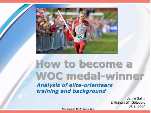
“How to become a WOC medal winner” (Janne Salmi), “How can we improved the quality of the o-technical training” (Eva Jurenikova) and “Developments in the international elite orienteering” (Janne Salmi) were three of the presentations presented at Elittränarträffen in Sweden which  should be very interesting to the readers of o-training.net.

60 of Swedens elite trainers within orienteering were present at the Elittränarträffen – with some very interesting sessions. See below for some of the content – and link to the full presentations at the bottom of this article.

“How to become a WOC medal winner” (Janne Salmi)

skills

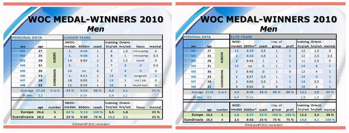
Janne Salmi presented the skills and qualities needed for a  top-orienteer based on a combination of previous knowledge and the coaches and athletes comments. Also included in the presentation was the background and training of the WOC medal-winners of Trondheim, both in their junior-years and in 2010.

There is a lot of interesting content in this presentation for anybody interested in getting to the top in orienteering. Some example content:

  • See above for big thumbnails of some slides related to how the skills and qualities vary through the years when going from a junior orienteer to an elite orienteer – this is of course also important related to where to put priorities in the training.
  • See below for big thumbnails of two slides related to training amount, 3000 meter times and some other data for the WOC 2010 medal winners both in their junior years and in their elite years.

You find the link to the complete presentation below – a lot of very interesting content here.
Presenting the skills and qualities needed for a
top-orienteer based on previous knowledge and
the coaches and athletes comments.
2. Presenting the background and training of the
WOC medal-winners of Trondheim, both in their
junior-years as in 2010.
3. “How to become a WOC medal-winner?”
Summary and take home messages for the
Scandinavian coaches.

skills2

“How can we improved the quality of the o-technical training” (Eva Jurenikova)

This presentation by Eva Jurenikova (Trainer of the Year in Sweden last year) is in Swedish language. The first part of the presentation is related to how important it is to have high quality in orienteering technical trainings – and also describing what is meant by high quality trainings. Some bullet-points,

  • High quality trainings gives motivation which again gives concentrated athletes. Concentration is needed in order to learn from the trainings.
  • Some tips for better concentration:  Use of GPS, A clear goal for each training, run in pairs, shorter trainings/divide a training into several shorter parts

Next there is some discussion about how to analysis your training/o-technical training. One of the tools mentioned here is 3DRerun (which is still in closed beta – I hope to get it out to you soon!) – another tool is statistics of mistakes.

The last part of the presentation gives a lot of nice training examples. Several of these are already in the orienteering exercises section of the O-training.net Wiki, but there are also several new ones which I’d like to get included in the o-training.net Wiki exercise section (please help out if you have time – you get an account for the o-training.net wiki here).

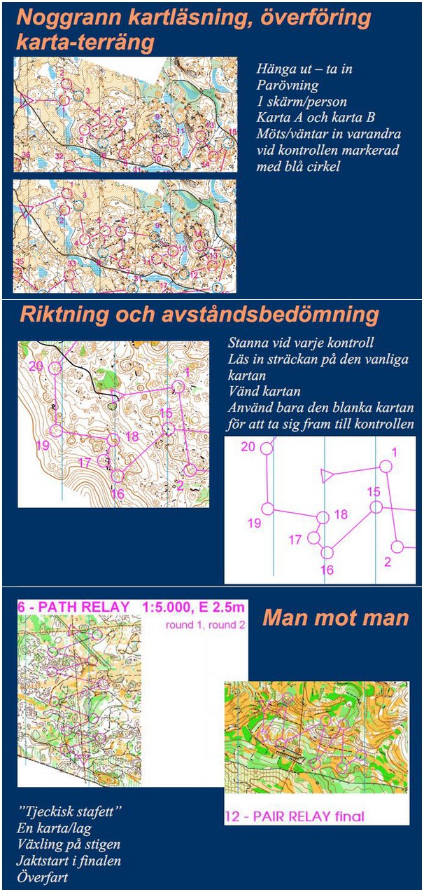
Below I have included three interesting exercises which I have not seen before – all of which seem to be very nice exercises.

  • The first exercise is a very good exercise for two persons on the same level when you have no controls in the forest. Each person carries one control – and there are two maps A/B. The runners meet at each blue control.
  • The second exercise is a direction exercise where you run on a course on a “white map”. There is a similar exercises in the o-training.net database (see also this one), the difference for the current exercise is that you stop at each control to take a look at the full map, and then run the leg on the white map. This introduces a new element of map memory, and you get closer to what you actually have in a competition situation.
  • The third exercise is the “Czech Relay” exercise which looks like a very nice high-speed exercise to train man-against-man. The course is back and forth over a road, and exchange is at each road crossing.

Find the link to the complete presentation of Jurenikova at the bottom of this page.
o-techneva

“Developments in the international elite orienteering” (Janne Salmi)

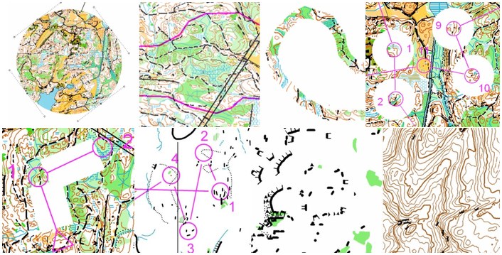
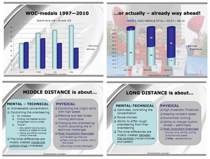
A very interesting presentation about the development in elite orienteering by Janne Salmi. Some parts of it are also interesting from an o-technical training point of view – especially the part about what the various disciplines are about (see the large thumbnails of a few slides below).

You find link to the complete presentation below.
salmi2

Full presentations

You find the link to the full presentations below – or alternatively in the “Overview articles” section of o-training.net where you also find a lot of other interesting resources related to o-technical training.

Analyzing your map reading technique – Automagically!

Posted by Jan Kocbach, 21 Nov 2010@16:00

Map reading sample from AMRD webpage
How often do you read the map – and how does it influence on your orienteering speed and the amount of mistakes you do? With an accelerometer attached to the map or to your hand – and combining this with GPS data – it is possible to display on a map at which locations and for how long a runner reads the map. This gives very interesting possibilities regarding analysis of what happens before a runner does a mistake – and also to see if the map reading frequency and length is optimal (see illustration above taken from AMRD webpage, © map: OLG Bern).

Swiss orienteer Michael Eglin has been working on a technique he denotes “Automated map reading detection (AMRD)” in which he uses an accelerometer (a device which can record its orientation relative to the ground) in order to record in which parts of the course a runner looks at the map. By combining this information with a GPS track of the route, the way the athlete reads the map can be analyzed.

Why is this interesting for you as an orienteer?

There are at least two very interesting applications for automated map reading detection:

  • Analysis of map reading technique compared to other athletes in order to determine if the map reading technique is optimal. For example to see if the map reading frequency is too high/low, if the map reading time is too long/short (can be coupled to other technical training), how map reading influences on running speed, stop-time at controls / out of controls / into controls for map reading, etc. Having a good map reading technique is vital for a top orienteer – see some discussion about map reading frequency in the o-training.net wiki. At a training camp with the Norwegian team before the 1999 WOC, they did a simple study of the number of times each runner looked at a map on a leg. The best men in the world that year — Petter Thoresen and Bjørnar Valstad — read the map more than 20 times on a 400 meter leg. Hanne Staff, who has been the best woman the last few years, read the map 15 times, while the worst of the women in the test read the map just 5 times.See here for an interesting comparison of map reading technique between two different runners – provided at the blog of Martin Lerjen (German text).
  • Analysis of map reading coupled to time losses for a specific race, for example to investigate the map reading ahead of mistakes to see if you can find a relation between too seldom/short map reading and a mistake and how much time you have used for route choices, etc. Martin Lerjen has done such a race specific analysis on his blog (and a second example) (German text) – finding several interesting results regarding the time losses and his map reading technique.
Examples from analysis

Martin Lerjen has done several interesting analysis using automated map reading detection – I have been allowed to provide some examples from Martin’s testing of the method here.

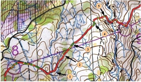
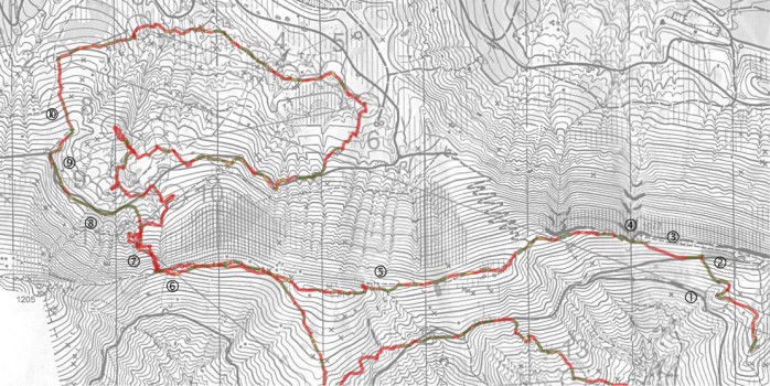
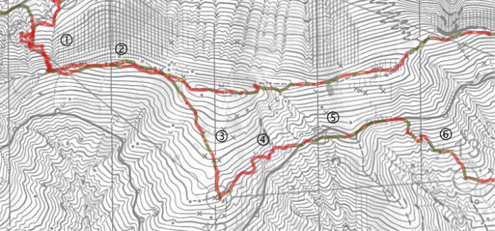
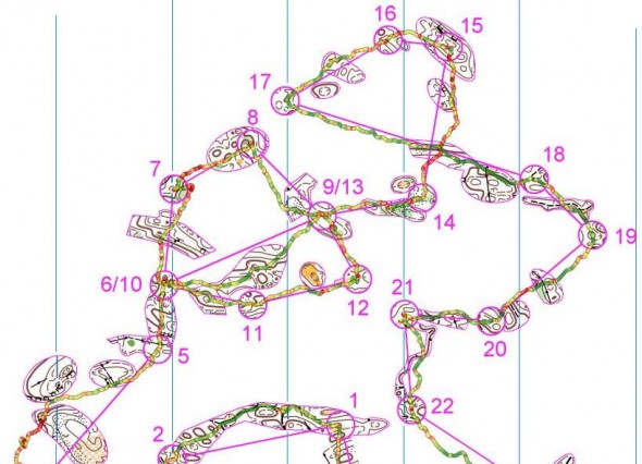
The first illustration is from a national race in Switzerland in October 2010 (Höhrohnen)- run by Martin Lerjen (see full analysis in German here). In the below illustration green color means mapreading – red means no mapreading (interchanging the colors might have been more intuitive?). From the map it is easy to see in which areas the runner reads the map, and in which areas there is no map reading. For this particular terrain there is quite a lot of red – i.e. running without reading the map.

02control

Zooming in on a particular location, you can see more details regarding the map reading technique.

04control

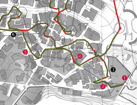
A second example provided is an example from a national sprint race in Einsiedeln, Switzerland (see the complete map in Routegadget here -  complete analysis in German see).  As you can see, there is a lot of mapreading involved in such a technical city sprint – most of the track being green.

01control

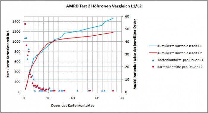
Finally, an example of comparing the map reading technique of two runners – this time again for the Höhrohnen case. The blue and red lines illustrate the accumulated map reading time of the two runners during the race – and the red/blue dots a histogram of length of map reading contacts (complete analysis in German here).

101014_Auswertung Vergleich

How does it work?

During map reading the hand of the athlete is in a typical position which is significantly different to the position during regular running. While reading the map, the athlete keeps the map close to horizontal – while the map is in a more vertical position while running. Thus, one can easily detect map reading by just recording the position of the hand. To do this, an accelerometer may be fixed to the map reading hand. The sensor moves and tilts with the hand, and from the recorded motion map reading events can be recognized.

See a full description of the method in the AMRD-webpage.

Equipment

Two electronic devices are needed – an accelerometer and a GPS logger. Eglin has been using a HOBO Pendant G Data Logger (Typ UA-004-64) from Onset as accelerometer which is available online for around 150 Euros. Any GPS logger with reasonable spatial resolution can be used (e.g. GARMIN GPS Watches) to track the runners position.

Mobile application

I started work on implementing this kind of accelerometer logging for logging of map reading time in a mobile application last year (as both Android phones and the iPhone/iPod touch have a built-in accelerometer which should have sufficient accuracy and frequency), but have not had time to finalize this work yet. It is, however, not a difficult task – and it should therefore be quite feasible to do this kind of analysis with holding your mobile phone or iPod touch under the map instead of buying a dedicated logger device. Some work is started for both an iPhone and Android application – I’ll try to get the work done during the winter months. If somebody else has worked on this already – please let me know in the comments. In a mobile phone, you can either use the built-in GPS or use an external GPS like a GPS watch (using an external GPS watch will give you better accuracy).

Keep it simple!

Posted by Jan Kocbach, 26 Sep 2010@22:11

Keep it simple!

This simplification exercise from the French Team WOC 2011 training camp in the Jura region found in the map archive of Vincent Coupat looks like a very good variant of the orienteering exercise “Run on a simplification map”. Making a good simplification exercise requires a lot of skill – and often making the exercise is even better training than running the exercise, as all of the simplification lies in making the map.

To get good value of running on a simplification map which you have not drawn yourself, it is important to do thorough work on analyzing the training afterwards. One part of this analysis could be to draw a new simplification map based on the outcome of the training.

Some resources related to simplification in o-training.net:

Maps from the WOC 2011 area on omaps.worldofo.com:

Routechoice Analysis Norwegian Champs Long H21

Posted by Jan Kocbach, 11 Sep 2010@21:16

The Norwegian Champs Long distance was organized in Indre Østfold today in a terrain which is very untypical for Norway. The terrain has many deep valleys, giving interesting routechoices. Below you find the routechoices of some of the best runners in the mens class on some of the decisive legs.

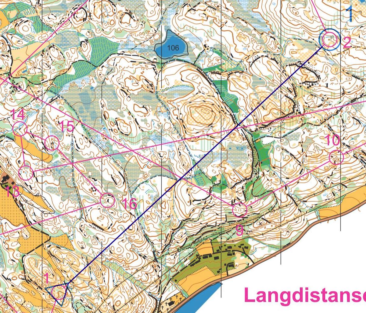
Before taking a look at the routechoices below, take a look at the course without routes here:

Note that all the split times given below are taken from the GPS tracking, and may differ by up to 10-15 seconds from the actual splits. Still, this is interesting for the routechoice analysis.

Leg 2-3

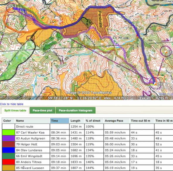
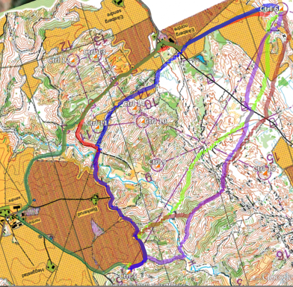
In the interview after the race, the winner Olav Lundanes told that his tactic was to run around in this hilly terrain to save energy. We see this already on the first long leg to the third control where Lundanes (dark blue) choose a variant to the right around the forbidden area. His main rival Carl Waaler Kaas choose a more direct route – like he did in most of the race – earning around 30 seconds on Lundanes on this particular leg. The two fastest of the top runners have chosen a left/direct approach on this leg.

At this point in the race, Waaler Kaas has a lead of around 40 seconds to Lundanes.

Screen shot 2010-09-11 at 7.52.04 PM

Leg 3-4

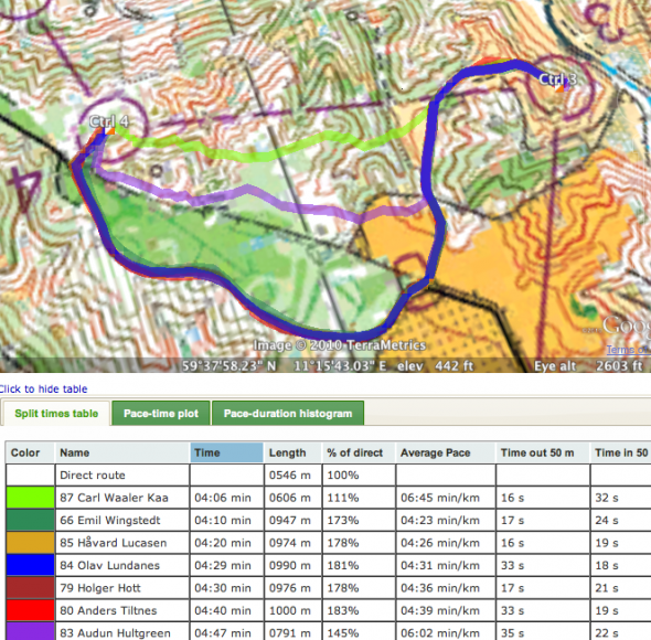
On leg 3-4 we again see that Lundanes goes far around to the left (80% longer than direct), while Waaler Kaas takes a more direct approach. And again Waaler Kaas is faster. Weltzien chooses a middle variant going through some green areas – loosing some time compared to the other runners.

Waaler Kaas has now increased his lead to Lundanes to nearly a minute.

Screen shot 2010-09-11 at 7.53.55 PM

Leg 5-6

The really long leg in this course was the leg from number 5 to number 6. Looking at the route choices of the top runners, we can see that the routes are spread over a wide area. Fastest of the top runners is Olav Lundanes (13:03) with a left variant in which he follows the field for the first part of the leg – running flat in high speed for large parts of the leg (34% longer than the direct line, average pace of 4:53 min/km). Waaler Kaas looses 45 seconds with a variant to the right which is much shorter (only 12% longer than the direct line with a lot of up and down, giving average pace of more than 6 min/km). Weltzien goes even further to the right, and is some seconds faster than Waaler Kaas. Wingstedt runs all the way around on the road to the left – running nearly 70% longer than the straight line with an average pace of 4:12 on the leg, being about one minute slower than Lundanes.

Waaler Kaas is still in the lead, but his lead has shrunk down to just above 10 seconds ahead of Lundanes in second spot.

Screen shot 2010-09-11 at 7.57.22 PM
Screen shot 2010-09-11 at 7.57.43 PM

Leg 6-19

The legs between 6 and 19 were not that interesting from a route choice perspective, but it was in this part of the course the race was decided. Waaler Kaas lost 2 minutes to control number 8 due to a mistake in the open, flat area. From 8 to 9, Waaler Kaas lost some time in the part with cliffs – and Lundanes choose some better micro route-choices on some of the other legs between control 9 and 18.

Leg 19-20

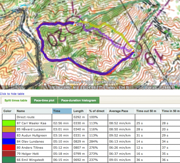
Again Waaler Kaas chooses a direct variant, whereas Lundanes goes around to the left. Lundanes runs 184% longer(!) than the straight line, and looses more than two minutes to Waaler Kaas who is fastest of the top runners on this leg. Tiltnes and Hott also go around to the left – running approximately the same time as Lundanes, whereas Wingstedt goes around to the right (137% longer), and looses even more than Lundanes.

This leg could have been very decisive for the overall victory, but Lundanes had a 4 minute lead on Waaler Kaas before the leg, and although Waaler Kaas got closer to Lundanes, the gap was still to big for Waaler Kaas to fight for the gold.

Screen shot 2010-09-11 at 8.01.22 PM

Summary

The course setter (Tore Sandvik) presented an interesting course with many route choice options. Carl Waaler Kaas choose the best option on most of the route choice legs with his direct route choices – however Lundanes might have saved more energy for the rest of the course due to his routes going around on the routechoice legs. I was not present at the championships – so I might have missed some points in the analysis above. If you have something to add to the analysis – either based on the GPS tracking, the splits, or because you were running – please add a comment below.

Results

Men 21

1 Lundanes, Olav Halden SK 01:34:12
2 Kaas, Carl Waaler Bækkelagets SK 01:35:18 +01:06
3 Weltzien, Audun Hultgreen Tyrving, IL 01:36:03 +01:51
4 Rollier, Baptiste Kristiansand OK 01:39:43 +05:31
5 Lucasen, Håvard Ås-UMB Orientering 01:39:53 +05:41
6 Karlsson, Mattias Halden SK 01:40:25 +06:13
7 Wingstedt, Emil Halden SK 01:42:52 +08:40
8 Tiltnes, Anders Tyrving, IL 01:43:23 +09:11
9 Hott, Holger Kristiansand OK 01:44:39 +10:27
9 Sagbereg, Torbjørn Tyrving, IL 01:44:39 +10:27

Women 21

1 Bagstevold, Heidi Østlid Bækkelagets SK 01:12:38
2 Wigemyr, Tone Bækkelagets SK 01:16:16 +03:38
3 Klechova, Vendula Halden SK 01:17:20 +04:42
4 Jahren, Silje Ekroll Raumar Orientering 01:18:41 +06:03
5 Holmström, Bodil NTNUI 01:20:54 +08:16
6 Bjørgul, Ida Marie Næss Halden SK 01:21:15 +08:37
7 Kahrs, Marianne Riddervold Fredrikstad SK 01:22:06 +09:28
8 Persson, Lina Kristiansand OK 01:23:25 +10:47
9 Bjerva, Elin Bækkelagets SK 01:23:41 +11:03
10 Palmer, Helen Suzanne Wing OK 01:25:42 +13:04
O-training.net

O-training.net will look into more interesting routechoice legs when the autumn darkness comes upon us the coming months. If you have legs or courses which are interesting for analysis, please send an email to jan@kocbach.net.

Also, remember that the O-training.net wiki is open to everybody for addition of o-training exercises and other stuff related to orienteering training. Please contribute!

O-technical training ahead of 10MILA

Posted by Jan Kocbach, 29 Apr 2010@5:00

When the old map from the competition area is available, it is always a good idea to do some theoretical o-technical training on the old map. For 10MILA, the old map is available (you could for example buy it from the 10MILA webpage). Most top teams and top runners have probably already made their preparations with the map – read on to see some of IFK Mora’s exercises.

IFK Mora has a very nice o-technical training webpage – in which most of their training exercises are shown. Eva Jurenikova – trainer of the year in Sweden in 2009 – is responsible for the training page. In December 2009, IFK Mora made theoretical o-technical training on the old 10MILA map – using the following exercises:

  • Exercise 1: Route choice. 7 different legs are shown with some route choice alternatives for each leg. The athletes shall choose the route they think is best, thinking either as a night orienteer or as a day orienteer (see also routechoice quizzes section of O-training.net)
  • Exercise 2: Tactics and drawing of simplification map. 10 different legs are given. For each leg, the athlete shall draw a simplification map, while thinking about the following points: Which object are to be passed, which lines are to be followed, what is easy to see in the forest, where do you have to be accurate with the direction, which object is the control placed on, etc. (see also drawing simplification maps in o-training.net)

The exercises are still online – you can click here to see the exercises on the old 10MILA 2010 map on IFK Mora’s webpage (Swedish language).

If you are running 10MILA on Saturday and haven’t yet taken a look at these exercises, you should definitely take some time to do it now!

Resources in o-training.net:

Webroute: Long leg in WOC relevant terrain

Posted by Jan Kocbach, 28 Apr 2010@5:00

Theoretical routechoice analysis is very good o-technical training – especially when you are forced to draw your route in Webroute. We will try to serve you some interesting webroutes/routechoice quizzes here at o-training.net – or point to other interesting ones. If you have some worth sharing, please add them in the comments here or directly to the o-training.net wiki at the appropriate place.

Resources in o-training.net related to routechoice exercises:

Chosen leg: Bjugn 25/4/2010

The chosen leg this time is from the long distance event in Bjugn close to Trondheim in Norway the previous weekend. This terrain has some WOC relevancy, and may therefore be of interest to many top runners. The leg is especially interesting due to the fact that there was full GPS tracking of all runners for this competition – the runners choosing a variety of different routes. First draw your route below – then take a look at the GPS tracking here.

Powered by WebRouteWorldofO.com

HowTo: Corridor Orienteering Exercises

Posted by Jan Kocbach, 15 Apr 2010@8:00

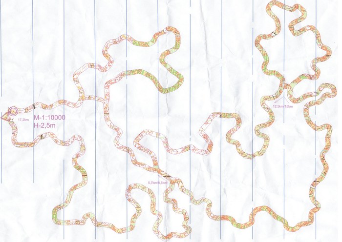
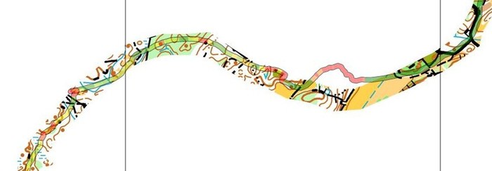
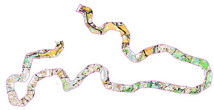
corr2_s

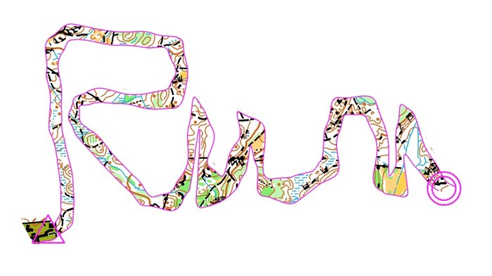
One of the best o-technical exercises for learning accurate map reading skills, is in my opinion Corridor Orienteering. As a bonus, the training can look very nice on the map as well. Corridor orienteering has existed as an o-technical exercise for many years ; earlier the corridor was made using a black covering pen – taking a lot of effort to make for a big group. Since OCAD and cheap color laser printers came around, you can make such a training in OCAD for 50 people in less than 10 minutes.

Read on for more thoughts about Corridor Orienteering – and a HowTo on how to make your own Corridor Orienteering exercises.

Training benefits

Using Corridor Orienteering you can force the athlete to use different techniques along the corridor due to the features available on the map inside the corridor. You can also make most terrains challenging – also terrains which the athlete has been in many times before. There are several other nice features about this type of training:

  • It requires no controls in the forest
  • The preparation time is short if you have access to OCAD and the OCAD file of the map
  • The training lends itself very well to GPS analysis after the training
  • As an athlete, you can make the corridor yourself without loosing much of the training effect (contrary to a normal course where you loose some effect due to map memory for route choices)

corr3_s

Aim of the exercise

The most important aim of the exercise is to learn accurate map reading, because the athlete is forced to know where he is and where he is going all the way along the corridor – as that is the only way to stay inside the corridor. Also, depending on how the corridor is made, the exercise may aim on forcing the athlete to use features in his orienteering which he usually does not use. In addition, straight parts can be used to train the athlete to keep the direction. Finally, this is also a good exercise to train on having a good flow in your orienteering – but that is only for elite orienteers.

Note that the athletes need to have a certain level to get full benefit of Cooridor Orienteering.

Training evaluation: GPS track

In my youth, I thought corridor orienteering training was boring. After the training, I never knew if I had performed well or not, and thus it was difficult to keep the motivation during the training. With the GPS evaluation you can use today, that has changed completely. Now the challenge is to keep your GPS track inside the corridor all of the way. Give yourself 10 push-ups extra for each time you are outside the corridor – and you’ll either get a good orienteer or strong arms…

corr4_s

HowTo: How to make one yourself

There are several different ways to make a Corridor Orienteering exercise. Two different methods are described here – both using OCAD. It is also straightforward to make a Corridor Orienteering exercise in Photoshop or similar if you have not got the OCAD file of the map, but this is not described here. Using the first method, you can make a typical training in less than 10 minutes.


Resources in O-training.net

Corridor orienteering resources in O-training.net:

Have you made a nice Corridor Orienteering training? Or have you got other interesting ideas for orienteering technical exercises? Either contribute directly in o-training.net which is a wiki-style site for o-technical training content by requesting an account, or add a comment below.

corr_s

O-training.net: Test-version ready

Posted by Jan Kocbach, 11 Apr 2010@14:00

otech2
An early version of o-training.net is now available for testing. O-training.net is a project which I have had in my mind for years, but which I never have got time to realize. The content can still only be considered to be a test-version, but in my opinion there is too much interesting stuff here to just leave it hidden and unpublished until I some time maybe would have time to finish it.

Wiki style

The main part of O-training.net is built up as a community-driven wiki, where everybody is allowed to contribute. In an ideal world, I would allow anonymous edits at O-training.net, but due to todays spam-problems in the Internet, you will have to request an account to contribute to O-training.net. O-training.net is part of WorldofO.com.

Main resource for O-Technical training

O-training.net was planned to be the main resource for Orienteering Technical training available online. O-training.net will try to gather all the resources available on the internet in one place. The intention is that this will be the place to go for everybody wanting to improve as an orienteer.

The main content will be O-training exercises, but other kind of resources like training camp sites, orienteering trainers, weblinks etc. will also be included. O-training.net is community-driven, and therefore in the end it is YOU who decide what these pages will contain.

A few links to get you started:

Early test-version

When using O-training.net, keep in mind that this is an early test-version which I would normally not consider ready for publishing.

Terrain types: Categorization

Posted by Jan Kocbach, 12 Nov 2009@1:09

One of the sections of O-training.net which it is very tricky to build, is the part describing different types of terrains. There are so many different types of o-terrain – and different terrain types often require different orienteering technique. In some areas, the cliffs are your best friend in your orienteering – as they are very distinct and visible from far away. In other areas, the single trees are your best navigation aids. In the ‘Terrain types’ section we try to categorize different terrain types.

Please head over to the Terrain types section and help us categorize different terrain types.

« Previous Page