New version of QuickRoute and DOMA!
Two of the most popular free orienteering software available – QuickRoute and DOMA – are now updated to version 2.4 and 3.02, respectively. All QuickRoute users should consider an update – the new features are a big plus in daily use of QuickRoute. Update of DOMA is somewhat more involved, but absolutely a worthy upgrade.
QuickRoute 2.4
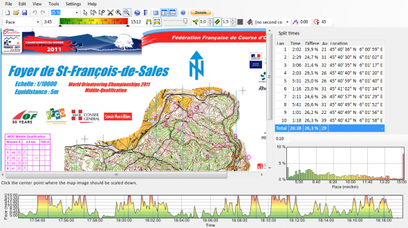
QuickRoute is the state-of-the-art tool for GPS-analysis of single GPS-tracks today – used by thousands of orienteers. See a full description of how to use QuickRoute for GPS-analysis here. The new version has the following improvements:
- Map images can be scaled, rotated and cropped when creating new documents.
- Route lines can be coloured according to two properties, for example both pace and heart rate.
- Thick lines supported while adjusting maps (this alone is worth the upgrade!)
- Support for the Garmin .fit file format.
- Import of Hearth rate data from Garmin HR files
- Improved integration with the new 3.0.2 version of DOMA (see below for info) – e.g. uploading of maps without route and with route.
- QuickRoute is now available in a number of new languages.
- Lots of other enhancements and bug fixes.
Download the new version here:
- QuickRoute download page
- Donate money to the developer Mats Troeng here – the donations is what makes the further development of the software possible. A suggestion is 10 to 20 Euros. In this way, you encourage the development of new versions.
DOMA 3.02
DOMA is a digital orienteering map archive, to be installed on a PHP+MySQL-equipped web server. The digital orienteering map archive helps you display your and your friends’ orienteering maps and route choices on the web. Since the first version was released in the end of 2008, DOMA has been installed on over 700 web servers, where 2 000 users have added more than 40 000 maps. You find nearly 30.000 of these DOMA maps in the DOMA section of omaps.worldofo.com along with a lot of other orienteering maps. If your DOMA-site is missing in omaps.worldofo.com, please send a note about it to jan@kocbach.net.
News in Doma 3.02:
- Maps can be commented by visitors.
- Added overview map feature where the geographical locations of the maps are shown.
- Map images without routes can be uploaded along with map images including routes, so visitors can plan their own route choices without actually revealing them.
- Maps may be hidden for others than the owner until a certain time.
- KML export, making it possible to open maps in Google Earth.
Download the new version from here:
