O-technical training ahead of 10MILA

Posted by Jan Kocbach, 29 Apr 2010@5:00

When the old map from the competition area is available, it is always a good idea to do some theoretical o-technical training on the old map. For 10MILA, the old map is available (you could for example buy it from the 10MILA webpage). Most top teams and top runners have probably already made their preparations with the map – read on to see some of IFK Mora’s exercises.

IFK Mora has a very nice o-technical training webpage – in which most of their training exercises are shown. Eva Jurenikova – trainer of the year in Sweden in 2009 – is responsible for the training page. In December 2009, IFK Mora made theoretical o-technical training on the old 10MILA map – using the following exercises:

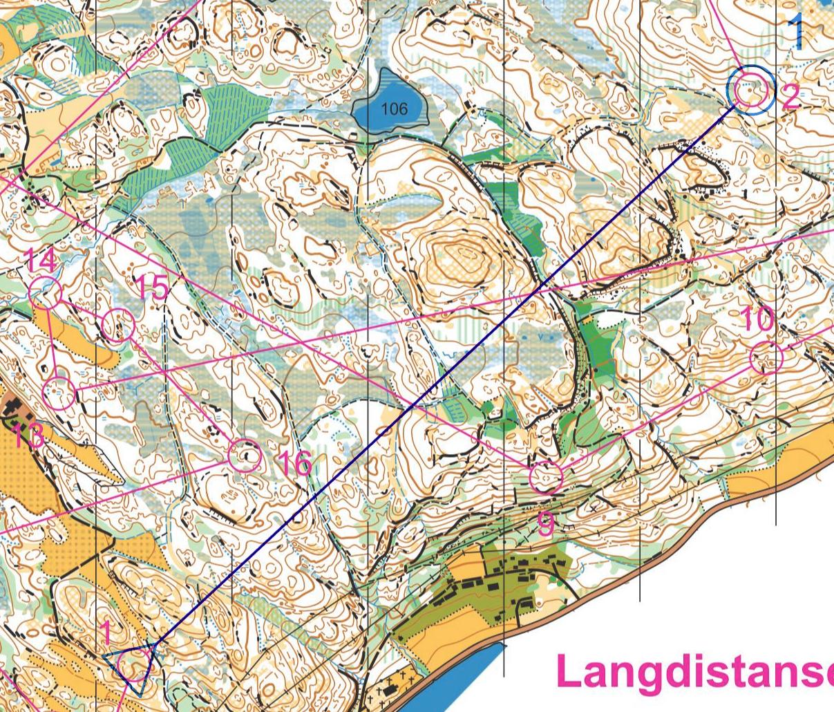
  • Exercise 1: Route choice. 7 different legs are shown with some route choice alternatives for each leg. The athletes shall choose the route they think is best, thinking either as a night orienteer or as a day orienteer (see also routechoice quizzes section of O-training.net)
  • Exercise 2: Tactics and drawing of simplification map. 10 different legs are given. For each leg, the athlete shall draw a simplification map, while thinking about the following points: Which object are to be passed, which lines are to be followed, what is easy to see in the forest, where do you have to be accurate with the direction, which object is the control placed on, etc. (see also drawing simplification maps in o-training.net)

The exercises are still online – you can click here to see the exercises on the old 10MILA 2010 map on IFK Mora’s webpage (Swedish language).

If you are running 10MILA on Saturday and haven’t yet taken a look at these exercises, you should definitely take some time to do it now!

Resources in o-training.net:

Webroute: Long leg in WOC relevant terrain

Posted by Jan Kocbach, 28 Apr 2010@5:00

Theoretical routechoice analysis is very good o-technical training – especially when you are forced to draw your route in Webroute. We will try to serve you some interesting webroutes/routechoice quizzes here at o-training.net – or point to other interesting ones. If you have some worth sharing, please add them in the comments here or directly to the o-training.net wiki at the appropriate place.

Resources in o-training.net related to routechoice exercises:

Chosen leg: Bjugn 25/4/2010

The chosen leg this time is from the long distance event in Bjugn close to Trondheim in Norway the previous weekend. This terrain has some WOC relevancy, and may therefore be of interest to many top runners. The leg is especially interesting due to the fact that there was full GPS tracking of all runners for this competition – the runners choosing a variety of different routes. First draw your route below – then take a look at the GPS tracking here.

Powered by WebRouteWorldofO.com

HowTo: Corridor Orienteering Exercises

Posted by Jan Kocbach, 15 Apr 2010@8:00

corr2_s

One of the best o-technical exercises for learning accurate map reading skills, is in my opinion Corridor Orienteering. As a bonus, the training can look very nice on the map as well. Corridor orienteering has existed as an o-technical exercise for many years ; earlier the corridor was made using a black covering pen – taking a lot of effort to make for a big group. Since OCAD and cheap color laser printers came around, you can make such a training in OCAD for 50 people in less than 10 minutes.

Read on for more thoughts about Corridor Orienteering – and a HowTo on how to make your own Corridor Orienteering exercises.

Training benefits

Using Corridor Orienteering you can force the athlete to use different techniques along the corridor due to the features available on the map inside the corridor. You can also make most terrains challenging – also terrains which the athlete has been in many times before. There are several other nice features about this type of training:

  • It requires no controls in the forest
  • The preparation time is short if you have access to OCAD and the OCAD file of the map
  • The training lends itself very well to GPS analysis after the training
  • As an athlete, you can make the corridor yourself without loosing much of the training effect (contrary to a normal course where you loose some effect due to map memory for route choices)

corr3_s

Aim of the exercise

The most important aim of the exercise is to learn accurate map reading, because the athlete is forced to know where he is and where he is going all the way along the corridor – as that is the only way to stay inside the corridor. Also, depending on how the corridor is made, the exercise may aim on forcing the athlete to use features in his orienteering which he usually does not use. In addition, straight parts can be used to train the athlete to keep the direction. Finally, this is also a good exercise to train on having a good flow in your orienteering – but that is only for elite orienteers.

Note that the athletes need to have a certain level to get full benefit of Cooridor Orienteering.

Training evaluation: GPS track

In my youth, I thought corridor orienteering training was boring. After the training, I never knew if I had performed well or not, and thus it was difficult to keep the motivation during the training. With the GPS evaluation you can use today, that has changed completely. Now the challenge is to keep your GPS track inside the corridor all of the way. Give yourself 10 push-ups extra for each time you are outside the corridor – and you’ll either get a good orienteer or strong arms…

corr4_s

HowTo: How to make one yourself

There are several different ways to make a Corridor Orienteering exercise. Two different methods are described here – both using OCAD. It is also straightforward to make a Corridor Orienteering exercise in Photoshop or similar if you have not got the OCAD file of the map, but this is not described here. Using the first method, you can make a typical training in less than 10 minutes.


Resources in O-training.net

Corridor orienteering resources in O-training.net:

Have you made a nice Corridor Orienteering training? Or have you got other interesting ideas for orienteering technical exercises? Either contribute directly in o-training.net which is a wiki-style site for o-technical training content by requesting an account, or add a comment below.

corr_s

O-training.net: Test-version ready

Posted by Jan Kocbach, 11 Apr 2010@14:00

otech2
An early version of o-training.net is now available for testing. O-training.net is a project which I have had in my mind for years, but which I never have got time to realize. The content can still only be considered to be a test-version, but in my opinion there is too much interesting stuff here to just leave it hidden and unpublished until I some time maybe would have time to finish it.

Wiki style

The main part of O-training.net is built up as a community-driven wiki, where everybody is allowed to contribute. In an ideal world, I would allow anonymous edits at O-training.net, but due to todays spam-problems in the Internet, you will have to request an account to contribute to O-training.net. O-training.net is part of WorldofO.com.

Main resource for O-Technical training

O-training.net was planned to be the main resource for Orienteering Technical training available online. O-training.net will try to gather all the resources available on the internet in one place. The intention is that this will be the place to go for everybody wanting to improve as an orienteer.

The main content will be O-training exercises, but other kind of resources like training camp sites, orienteering trainers, weblinks etc. will also be included. O-training.net is community-driven, and therefore in the end it is YOU who decide what these pages will contain.

A few links to get you started:

Early test-version

When using O-training.net, keep in mind that this is an early test-version which I would normally not consider ready for publishing.