Brown map
From O-training.net
Orienteering Exercise: Brown map
Key information
| Exercise Type: | Contours, Map reading |
|---|---|
| Target Level: | Elite level, Junior level, Intermediate level |
| Intensity: | Low, High |
| Preparation time: | 15-30 minutes |
| OCAD Required: | Yes |
| Min participants: | 1 |
 | |
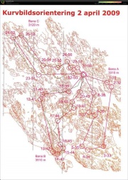
A course on a contour-only map (brown map). The runner must focus on the contours in his/her orienteering as this is the only information on the map. Many variants are given.
| Aim: | Understand and use contours efficiently in your orienteering. |
|---|---|
| Variants: | Variant A: Normal course on a contour map. Variant B: Competition on a contour map. Variant C: Circular contour map without north lines. Variant D: Corridor orienteering or Line orienteering on a contour map. |
| Aids: | OCAD is required in order to make the contour-only mpa. |
| Terrain: | Not good in terrain with very varying runnability if not vegetation details are included. |
| Preparations: | A contour-only map must be made in OCAD by removing all other details. See Tips_on_OCAD_usage for tips on how to make the contour-only map. |
| Tips: | Include some other details, e.g. roads/houses, in addition to contours, especially for non-elite runners. Some vegetation features (e.g. dark green) and other details which make it impossible to get through should be included in many cases. |
| Examples: |
Please Log in to contribute to O-training.net
O-training.net Blog articles:
- World Cup Long Spain: Quick GPS analysis
- WinSplits Pro for Iphone: Quick Review
- Gueorgiou: How to master the compass
- HeadCam analysis with local videos in 2DRerun
- What is effective technical training?
- RouteChoice Challenge: Long decisive leg in Swiss Champs Long
- WebRoute: Route choice leg Canada
- 2DRerun: Two very WOC Middle relevant races
- EOC Long Final: GPS Analysis
- EOC Middle Final: GPS Analysis
Useful links: