Reduced map compass training
From O-training.net
Orienteering Exercise: Reduced map compass training
Key information
| Exercise Type: | Compass |
|---|---|
| Target Level: | Elite level, Junior level |
| Intensity: | Low, Medium |
| Preparation time: | 15-30 minutes |
| OCAD Required: | Yes |
| Min participants: | 1 |
 | |
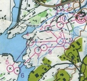
Make a course on a reduced map, where the reduced map is made by removing many details in such a way that the compass is the only option for orienteering. For example, you can have a map with only black details left. Use this for compass training.
| Aim: | Learn to use the compass better. Also learn to use details you don't always use in your orienteering. |
|---|---|
| Variants: | See also Reduced map training. |
| Aids: | OCAD is required. See Tips_on_OCAD_usage. |
| Terrain: | Quite flat terrain. |
| Preparations: | Make the reduced map, and set a course on the map. |
| Tips: | This is a good alternative compass training - which looks very nice on the map. It may also make it easier to have compass training in more hilly terrain as the runner can use the compass from feature to feature. |
| Examples: |
Please Log in to contribute to O-training.net
O-training.net Blog articles:
- World Cup Long Spain: Quick GPS analysis
- WinSplits Pro for Iphone: Quick Review
- Gueorgiou: How to master the compass
- HeadCam analysis with local videos in 2DRerun
- What is effective technical training?
- RouteChoice Challenge: Long decisive leg in Swiss Champs Long
- WebRoute: Route choice leg Canada
- 2DRerun: Two very WOC Middle relevant races
- EOC Long Final: GPS Analysis
- EOC Middle Final: GPS Analysis
Useful links: