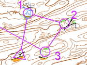
Gradual reduced maps with crop objects
From O-training.net
Orienteering Exercise: Gradual reduced maps with crop objects
Key information
Create gradual reduced/simplified maps that contain more information around the controls than between them
| Aim: | 1. Simplify map reading on a certain part of a leg
2. Detailed map reading near the controls |
|---|---|
| Variants: | It's a variant between windows and reduced maps. |
| Aids: | OCAD (version 11 standard) |
| Terrain: | |
| Preparations: | |
| Tips: | The course should contain also long legs. |
| Examples: |
1. Open map in OCAD 11 Standard 2. Draw an area over the map and cut holes out of it 3. Select the drawn object 4. Select symbol that should be cropped 5. Use Crop function in Object menu
Please Log in to contribute to O-training.net
O-training.net Blog articles:
- World Cup Long Spain: Quick GPS analysis
- WinSplits Pro for Iphone: Quick Review
- Gueorgiou: How to master the compass
- HeadCam analysis with local videos in 2DRerun
- What is effective technical training?
- RouteChoice Challenge: Long decisive leg in Swiss Champs Long
- WebRoute: Route choice leg Canada
- 2DRerun: Two very WOC Middle relevant races
- EOC Long Final: GPS Analysis
- EOC Middle Final: GPS Analysis
Useful links:
