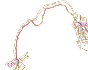
Follow the contour
From O-training.net
Orienteering Exercise: Follow the contour
Key information
| Exercise Type: | Contours, GPS evaluation |
|---|---|
| Target Level: | Elite level, Junior level |
| Intensity: | Low, Medium |
| Preparation time: | More than 30 minutes |
| OCAD Required: | Yes |
| Min participants: | 1 |
 | |
Course where only a single contour is shown between controls (or between some of the controls). Good to use GPS in evaluation of the training.
| Aim: | Be able to follow the height/follow a contour accurately. |
|---|---|
| Variants: | Combine this with a normal Brown map training. |
| Aids: | OCAD needed in order to remove all details except for the single contour. |
| Terrain: | |
| Preparations: | A contour-only map must be made in OCAD by removing all other details. See Tips_on_OCAD_usage for tips on how to make the contour-only map. You then have to remove all details except for a single contour. |
| Tips: | |
| Examples: | http://omaps.worldofo.com/index.php?id=21686
|
Please Log in to contribute to O-training.net
O-training.net Blog articles:
- WOC Sprint Relay 2015: BIG GPS & Splits Analysis
- World Cup Long Spain: Quick GPS analysis
- WinSplits Pro for Iphone: Quick Review
- Gueorgiou: How to master the compass
- HeadCam analysis with local videos in 2DRerun
- What is effective technical training?
- RouteChoice Challenge: Long decisive leg in Swiss Champs Long
- WebRoute: Route choice leg Canada
- 2DRerun: Two very WOC Middle relevant races
- EOC Long Final: GPS Analysis
Useful links:
