No-map compass training
From O-training.net
| (One intermediate revision not shown) | |||
| Line 1: | Line 1: | ||
{{Orienteering exercises | {{Orienteering exercises | ||
| - | |Exercise Types=Compass | + | |Exercise Types=Compass, Distance evaluation, GPS evaluation |
|Description=A course on a white sheet of paper with only the course drawn (no details at all). | |Description=A course on a white sheet of paper with only the course drawn (no details at all). | ||
|Aim=Train the use of compass. | |Aim=Train the use of compass. | ||
| Line 14: | Line 14: | ||
|Tips=Use GPS to evaluate the training - that is more motivating. [[Compass training in pairs]] is a good way to use this exercise for runners who are not that experienced. | |Tips=Use GPS to evaluate the training - that is more motivating. [[Compass training in pairs]] is a good way to use this exercise for runners who are not that experienced. | ||
|Terrain=Quite flat terrain should be used. It should be possible to run straight on the line. | |Terrain=Quite flat terrain should be used. It should be possible to run straight on the line. | ||
| + | |Examples=http://omaps.worldofo.com/index.php?id=20594 | ||
}} | }} | ||
Current revision as of 09:57, 11 April 2010
Orienteering Exercise: No-map compass training
Key information
| Exercise Type: | Compass, Distance evaluation, GPS evaluation |
|---|---|
| Target Level: | Elite level, Junior level |
| Intensity: | Low, Medium |
| Preparation time: | Less than 5 minutes |
| OCAD Required: | Yes |
| Min participants: | 1 |
 | |
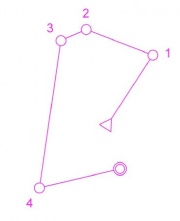
A course on a white sheet of paper with only the course drawn (no details at all).
| Aim: | Train the use of compass. |
|---|---|
| Variants: | This is one of many variants of compass orienteering. You may also remove only part of the area between the controls (see e.g. Fog training). The blank map variant is very easy /fast to make, and very tricky in the forest. Note that Compass training in pairs is a good way to use this exercise for runners who are not that experienced. |
| Aids: | OCAD is required in order to make the map. GPS is good for evaluation. |
| Terrain: | Quite flat terrain should be used. It should be possible to run straight on the line. |
| Preparations: | Make course without background map. See Tips_on_OCAD_usage for tips on how to make it in OCAD. |
| Tips: | Use GPS to evaluate the training - that is more motivating. Compass training in pairs is a good way to use this exercise for runners who are not that experienced. |
| Examples: | http://omaps.worldofo.com/index.php?id=20594 |
Please Log in to contribute to O-training.net
O-training.net Blog articles:
- WOC Sprint Relay 2015: BIG GPS & Splits Analysis
- World Cup Long Spain: Quick GPS analysis
- WinSplits Pro for Iphone: Quick Review
- Gueorgiou: How to master the compass
- HeadCam analysis with local videos in 2DRerun
- What is effective technical training?
- RouteChoice Challenge: Long decisive leg in Swiss Champs Long
- WebRoute: Route choice leg Canada
- 2DRerun: Two very WOC Middle relevant races
- EOC Long Final: GPS Analysis
Useful links: