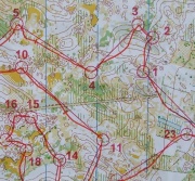
Map without paths
From O-training.net
Orienteering Exercise: Map without paths
Key information
| Exercise Type: | Map reading, Map contact |
|---|---|
| Target Level: | Elite level, Junior level, Intermediate level |
| Intensity: | Low, Medium, High |
| Preparation time: | 15-30 minutes |
| OCAD Required: | Yes |
| Min participants: | 1 |
 | |
Make a course on a map from which all paths have been removed.
| Aim: | Make the orienteering on a map with many paths more challenging, making it more usable for training. |
|---|---|
| Variants: | You may also remove even more features - see Reduced map training. |
| Aids: | OCAD is required to remove the paths. See Tips_on_OCAD_usage. |
| Terrain: | |
| Preparations: | Make the reduced map, and set a course on the map. |
| Tips: | |
| Examples: |
Please Log in to contribute to O-training.net
O-training.net Blog articles:
- WOC Sprint Relay 2015: BIG GPS & Splits Analysis
- World Cup Long Spain: Quick GPS analysis
- WinSplits Pro for Iphone: Quick Review
- Gueorgiou: How to master the compass
- HeadCam analysis with local videos in 2DRerun
- What is effective technical training?
- RouteChoice Challenge: Long decisive leg in Swiss Champs Long
- WebRoute: Route choice leg Canada
- 2DRerun: Two very WOC Middle relevant races
- EOC Long Final: GPS Analysis
Useful links: