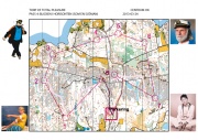
Sailor Training
From O-training.net
| Line 1: | Line 1: | ||
{{Orienteering exercises | {{Orienteering exercises | ||
|Exercise Types=Simplification, Flow, Route planning | |Exercise Types=Simplification, Flow, Route planning | ||
| - | |Description=The athlete should follow a opaque line on the map which width is adapted to the terrain. The athlete is that way forced to navigate with objects alongside his direct route. At some control points even the controls object might be removed. | + | |Description=The athlete should follow a opaque line on the map which width is adapted to the terrain. The athlete is that way forced to navigate with objects alongside his direct route. At some control points even the controls object might be removed. |
|Aim=In this exercise the athlete trains to keep a broad perspective, let's call it the sailor perspective, ahead and to the sides building the base for fluid orienteering. | |Aim=In this exercise the athlete trains to keep a broad perspective, let's call it the sailor perspective, ahead and to the sides building the base for fluid orienteering. | ||
|Target Level=Elite level, Junior level, Intermediate level, Beginner level | |Target Level=Elite level, Junior level, Intermediate level, Beginner level | ||
Current revision as of 22:17, 4 April 2013
Orienteering Exercise: Sailor Training
Key information
The athlete should follow a opaque line on the map which width is adapted to the terrain. The athlete is that way forced to navigate with objects alongside his direct route. At some control points even the controls object might be removed.
| Aim: | In this exercise the athlete trains to keep a broad perspective, let's call it the sailor perspective, ahead and to the sides building the base for fluid orienteering. |
|---|---|
| Variants: | Depending on the line you are giving the exercise is more aimed on working with beacons or may get an additional "compass-element" between beacons. |
| Aids: | You can modify the basemap with OCAD but you also can just use some correction tape to cover the route line |
| Terrain: | Good view. |
| Preparations: | Preparing the map, setting controls. |
| Tips: | Take it serious! It is pretty hard to succeed. |
| Examples: | http://www.centrumkartor.se/show_map.php?user=pscom&map=419 |
Please Log in to contribute to O-training.net
O-training.net Blog articles:
- WOC Sprint Relay 2015: BIG GPS & Splits Analysis
- World Cup Long Spain: Quick GPS analysis
- WinSplits Pro for Iphone: Quick Review
- Gueorgiou: How to master the compass
- HeadCam analysis with local videos in 2DRerun
- What is effective technical training?
- RouteChoice Challenge: Long decisive leg in Swiss Champs Long
- WebRoute: Route choice leg Canada
- 2DRerun: Two very WOC Middle relevant races
- EOC Long Final: GPS Analysis
Useful links:
