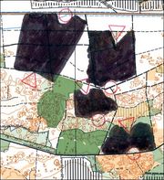
Remove map between controls
From O-training.net
Orienteering Exercise: Remove map between controls
Key information
| Exercise Type: | Compass, Relocation |
|---|---|
| Target Level: | Elite level, Junior level, Intermediate level |
| Intensity: | Low, Medium, High |
| Preparation time: | Less than 5 minutes |
| OCAD Required: | No |
| Min participants: | 1 |
 | |
Exercise for compass orienteering in which the area between controls is erased using OCAD or drawn black using a covering marker pen. You need to relocate with the features available when you come into the part with map.
| Aim: | Learn to run on accurate compass course without any other map reading. |
|---|---|
| Variants: | Possible to use star-orienteering or small loops in order to use the best parts of the terrain. |
| Aids: | Either OCAD or a black covering marker pen. |
| Terrain: | Rather flat terrain. |
| Preparations: | The preparation time is higher for OCAD (15-20 minutes) than for the case with a black covering marker pen - depending on the number of participants.
Make a normal orienteering course, preferably in flat terrain. Cover the area between control with a black marker pen - or alternatively if using OCAD, remove the area between the controls in OCAD. For the latter, see Tips on OCAD usage. |
| Tips: | Use flat terrain if possible. Try to have a path/road or other clearly identifiable features behind the controls (and also visible on the map) to avoid big time-consuming mistakes. Ask the participants to note (and make statistics) about which side of the control they land at (left or right or straight hit) including distance from the control. Use GPS to see how well the runners perform. |
| Examples: |
Please Log in to contribute to O-training.net
O-training.net Blog articles:
- WOC Sprint Relay 2015: BIG GPS & Splits Analysis
- World Cup Long Spain: Quick GPS analysis
- WinSplits Pro for Iphone: Quick Review
- Gueorgiou: How to master the compass
- HeadCam analysis with local videos in 2DRerun
- What is effective technical training?
- RouteChoice Challenge: Long decisive leg in Swiss Champs Long
- WebRoute: Route choice leg Canada
- 2DRerun: Two very WOC Middle relevant races
- EOC Long Final: GPS Analysis
Useful links: